Urban design adapted to climate change with PALM-4U

“The summer of 2022 in Germany was the sunniest, the 6th driest and one of the four warmest on record,” reported the German Weather Service (DWD). In Europe alone, it caused over 60,000 heat-related deaths. In view of rising temperatures, it is crucial that towns and cities take measures to adapt to the consequences of climate change in order to become more resilient. This is the only way to reduce the impact of urban heat on the health of inhabitants.

Evidence-based planning of adaptation measures, such as green spaces, fresh air corridors, sunshading, etc., can lower inner city temperatures, improve the urban climate and therefore prevent deaths. We can provide experts around the world with the tools they need to design urban areas in line with climate change.

Urban climate simulations with the PALM-4U model enable municipal employees and urban planners to identify stress points with pinpoint accuracy and to calculate the impact of adaptation measures even before they are implemented. The effectiveness and cost-benefit ratio of the measures can thus be optimized.

This simulation model is already freely available as an open source solution. Based on this, we offer a user-friendly user interface, the PALM-4U GUI. As part of a co-creation process, this was regularly tested together with municipal users during its development and implemented by them to deal with typical urban climate issues. It is therefore optimized for easy use by urban planning experts.

Would you like to find out more about the possibilities of our GUI and other urban planning services adapted to climate change? We have prepared information for you in various videos and infographics:

PALM-4U at a glance!

Find out more about the functions of PALM-4U in our infographics.

infographic urban design adapted to climate change
© Fraunhofer IBP
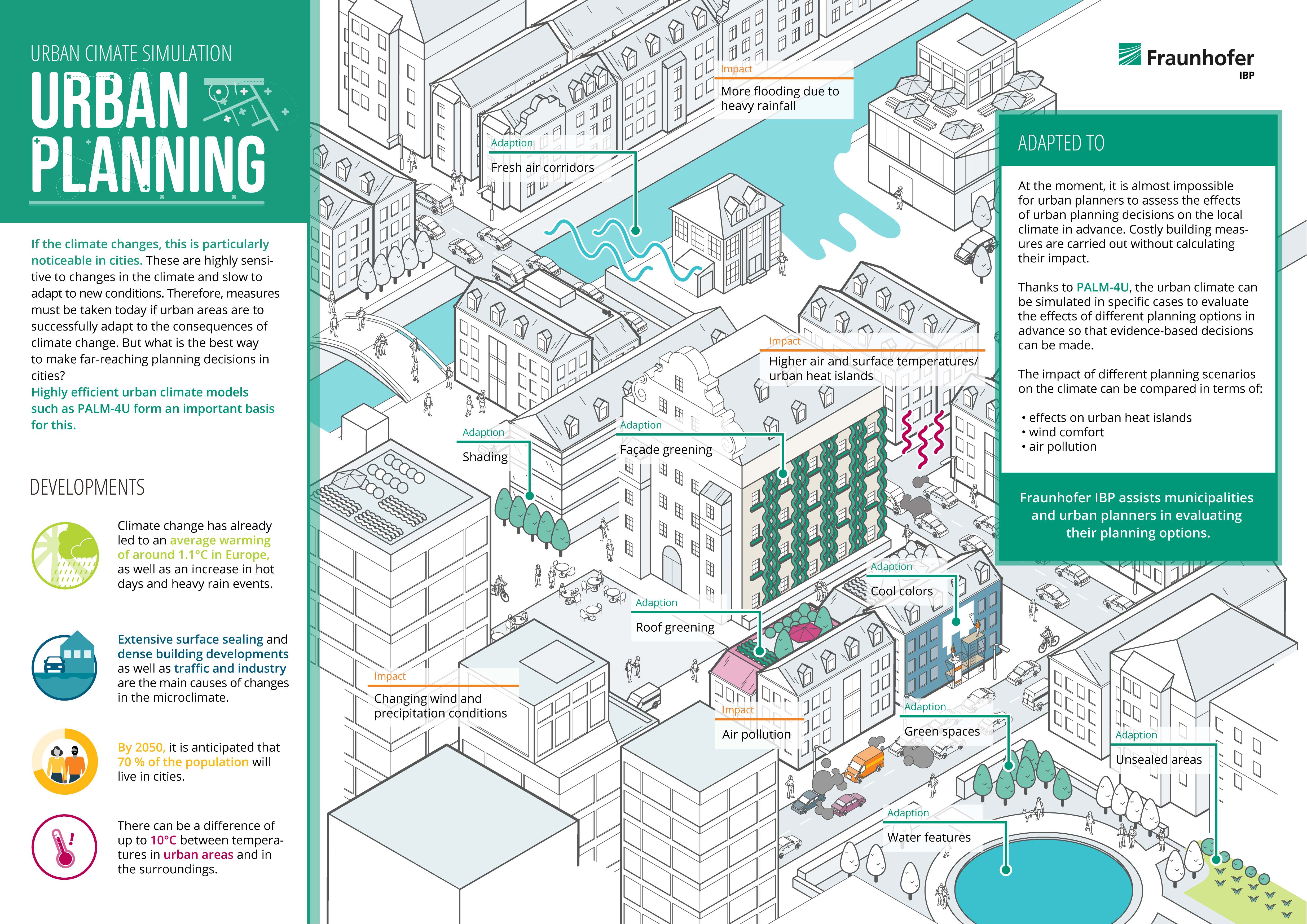
Planning and implementing adaptation measures in a targeted way increases the resilience of towns and cities to the consequences of climate change. The infographic shows which developments are challenging urban areas and how to overcome them.
Infographic: Urban climate simulations with the PALM-4U software
© Fraunhofer IBP
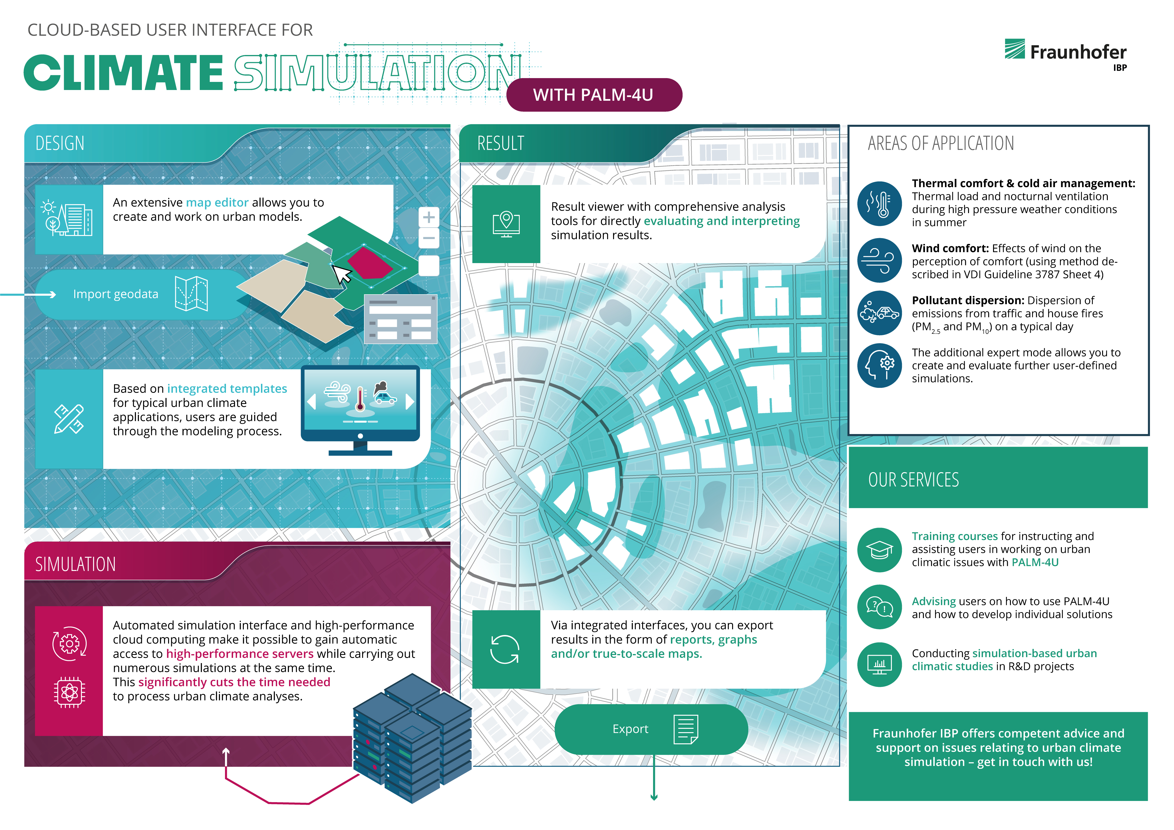
Urban climate simulations with the PALM-4U software enable municipal employees and urban planners to assess the impact of individual adaptation measures on the urban climate even before they are implemented. This infographic gives you an overview of the various software components and services offered by Fraunhofer IBP.

Urban climate simulation with PALM-4U GUI − advantages and benefits

Privacy warning

With the click on the play button an external video from www.youtube.com is loaded and started. Your data is possible transferred and stored to third party. Do not start the video if you disagree. Find more about the youtube privacy statement under the following link: https://policies.google.com/privacy

To make decisions for more climate-friendly urban planning before expensive construction measures have to be implemented - this is the aim of the highly efficient urban climate model PALM-4U. Planners in cities and municipalities can use the model to carry out climate simulations and test different planning versions in advance so that they can assess their impact on the urban climate.

Urban climate simulation with PALM-4U GUI − use and functions

When developing the PALM-4U urban climate model, it was important to our researchers to make everything available in one interface, the PALM-4U GUI. This standardizes the workflow. In addition to the editor for the urban models, there are various template systems for creating model setups as well as tools for evaluating the results.

Privacy warning

With the click on the play button an external video from www.youtube.com is loaded and started. Your data is possible transferred and stored to third party. Do not start the video if you disagree. Find more about the youtube privacy statement under the following link: https://policies.google.com/privacy

Urban climate simulation with PALM-4U GUI − citizen participation

Privacy warning

With the click on the play button an external video from www.youtube.com is loaded and started. Your data is possible transferred and stored to third party. Do not start the video if you disagree. Find more about the youtube privacy statement under the following link: https://policies.google.com/privacy

How can the effects of urban planning measures on the urban climate be communicated in a way that is understandable to laypersons? In the “UCare4Citizens” project, users can implement augmented reality to see what the urban climate in their own district looks like today, what measures are possible and how these affect the area both individually and in total.